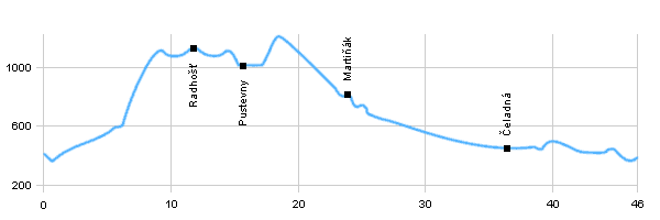
| Dist. |
Location |
Elevation |
Marking |
Description |
| 0,0 |
Frenštát pod Radhoštěm |
410 m n.m. |
|
 roads and local roads roads and local roads |
| 3,2 |
Trojanovice |
500 m n.m. |
 |
 cycle way no. 6016 cycle way no. 6016 |
| 10,2 |
Pustevny |
980 m n.m. |
 |
on the edge to statue of Radegast |
| 12,7 |
Radhošť |
1129 m n.m. |
|
back to Pustevna |
| 15,2 |
Pustevny |
980 m n.m. |
 |
 cycle way no. 46 cycle way no. 46 |
| 23,7 |
Martiňák |
830 m n.m. |
|
 cycle way no. 46 cycle way no. 46 |
| 36,2 |
Čeladná |
430 m n.m. |
|
 road 483 road 483 |
| 46,0 |
Frenštát pod Radhoštěm |
410 m n.m. |
|
|
| | long rising | | | long rising on the asphalt forest roads | | | First the asphalt road, then along the forest trail | | | steep descent on the beginning, asphalt road from Podolánky | | | beutiful view to Beskydy |
|


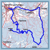 Click to show full-size map