|
|
|
|
|
||||||||||
|
|
|
||||||||||||


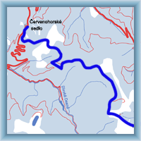
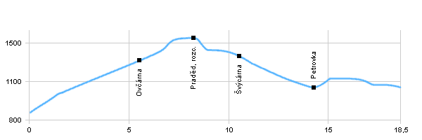
Cycling routes - From Hvězda to gap Červenohorské sedlo
|
Length: 18,5 km Dificulty: difficult Bikes: Difficult trail with big super elevation in both directions, leads between Hvězda and Švýcárna on the road, after that leads on the forest road. One of the most visited places in Czech Republic. We recommend inform about actual weather forecast. |
|
 Click to show full-size map
| ||||||||||||||||||||||||||||||||||||||||||||||||||
| ||||||||||||||||||||||||||||||||||||||||||||||||||||

|
