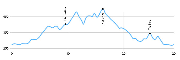
Length: 29 km
Dificulty: easy
Bikes: road bike, cross bike, mountain bike
Easy trail, which starts and finish in Staiňanech. The trace leads through Rabštejn, Slavice, Nasavrky, Libáň back to Slatiňany. The trail leads mainly on roads of III. class.

|
|
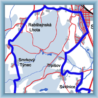 Click to show full-size map
|
| Dist. |
Location |
Elevation |
Marking |
Description |
| 0,0 |
Slatiňany |
275 m n.m. |
 |
 cycle way no. 4112, crossroad with cycle ways no. 4113 and no. 4194 cycle way no. 4112, crossroad with cycle ways no. 4113 and no. 4194 |
| 4,0 |
Rabštejnská Lhota |
305 m n.m. |
|
 road no. II/340 road no. II/340 |
| 6,0 |
Rabštejn |
375 m n.m. |
|
 cycle way no. 4185, road II/340 cycle way no. 4185, road II/340 |
| 7,0 |
Smrkový Týnec |
383 m n.m. |
|
cycle way no. 4177 |
| 9,5 |
Licibořice |
403 m n.m. |
|
 crossroad of cycle ways no. 4177 with cycle way without no. crossroad of cycle ways no. 4177 with cycle way without no. |
| 12,0 |
Slavice |
435 m n.m. |
 |
 |
| 14,0 |
Hradiště |
455 m n.m. |
 |
 cycle way no. 4114 cycle way no. 4114 |
| 16,0 |
Nasavrky |
500 m n.m. |
|
 crossroad with cycle way no. 4114 and no. 4121 crossroad with cycle way no. 4114 and no. 4121 |
| 18,5 |
Drahotice |
415 m n.m. |
|
cycle way no. 4121 |
| 19,0 |
Libáň |
390 m n.m. |
|
 road I/37 road I/37 |
| 23,5 |
Svídnice u Slatiňan |
295 m n.m. |
|
 |
| 25,0 |
Trpišov |
345 m n.m. |
|
cycle way no. 4112, crossroad with cycle way no. 4118 |
| 29,0 |
Slatiňany |
275 m n.m. |
|
|
| | castle, church | | | Natural Monument Na skalách - geological location, natural swimming pool | | | The ruins of the castle from the 14th century. | | | Baroque church belfry | | | settlement in Slavický field, horses, deer and mouflons | | | Instead of Celtic settlement, evangelical church with Baroque elements Empire | | | castle, church | | | three ponds with oak | | | protected tree |
|