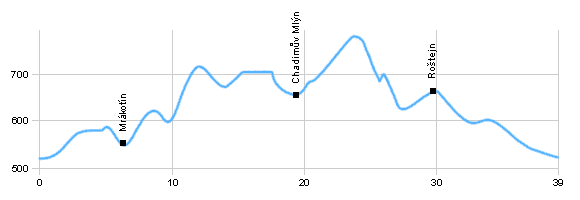
| Dist. |
Location |
Elevation |
Marking |
Description |
| 0,0 |
Telč |
510 m n.m. |
 |
cycle way no. 1113 |
| 5,2 |
Mrákotín |
545 m n.m. |
|
 cycle way no. 1113 cycle way no. 1113 |
| 12,5 |
Crossroad by lake Karhov |
670 m n.m. |
|
cycle way no. 1162 |
| 16,5 |
Kaliště |
686 m n.m. |
|
road 134 |
| 18,0 |
Chadimův mlýn |
660 m n.m. |
|
 cycle way no. 5126 cycle way no. 5126 |
| 24,9 |
Crossroad of blue, red and green cycle ways |
700 m n.m. |
 |
 cycle way no. 5021 cycle way no. 5021 |
| 29,5 |
Roštejn |
667 m n.m. |
|
 cycle way no. 15 cycle way no. 15 |
| 39,0 |
Telč |
510 m n.m. |
|
|
| | steep rising in the front of Světlá | | | gradual rising, you can shorten following the red over the hill Míchův(786 m) | | | hilly terrain | | | descent back to Telče |
|


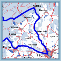 Click to show full-size map