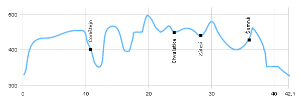
| Dist. |
Location |
Elevation |
Marking |
Description |
| 0,0 |
Vranov nad Dyjí |
330 m n.m. |
|
 road 39810 road 39810 |
| 4,4 |
Lančov |
430 m n.m. |
|
 local road local road |
| 10,8 |
Castle Cornštejn |
400 m n.m. |
 |
 cycle way no. 5007 cycle way no. 5007 |
| 12,3 |
Vysočany |
435 m n.m. |
|
 cycle way no. 5011 cycle way no. 5011 |
| 20,7 |
Popelná |
445 m n.m. |
|
cycle way no. 5007 |
| 22,5 |
Chvalatice |
450 m n.m. |
|
 cycle way no. 5007 cycle way no. 5007 |
| 27,6 |
Zálesí |
445 m n.m. |
|
cycle way no. 5007 |
| 34,9 |
Šumná |
438 m n.m. |
 |
road no. 398 |
| 35,9 |
Lesná - bus station |
445 m n.m. |
|
 turn left down to the long-distance route E8 turn left down to the long-distance route E8 |
| 42,1 |
Vranov nad Dyjí |
330 m n.m. |
|
|
| | slight descent behind Vranov | | | descent | | | climb, but after a comfortable journey | | | perhaps turning to the red marked path to castle Bítov | | | we are connecting to the road, so look for traffic | | | descent to the dam |
|


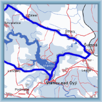 Click to show full-size map