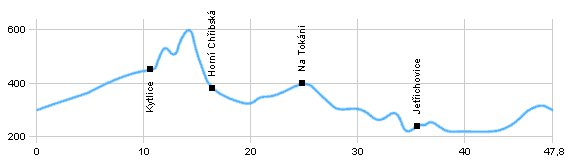
| Dist. |
Location |
Elevation |
Marking |
Description |
| 0,0 |
Česká Kamenice |
300 m n.m. |
 |
 cycle way n. 21 cycle way n. 21 |
| 4,5 |
Fredevald |
350 m n.m. |
|
cycle way n. 21 |
| 8,5 |
Mlýny railway station |
430 m n.m. |
|
cycle way n. 21 |
| 10,5 |
Kytlice |
450 m n.m. |
|
 cycle way n. 211 cycle way n. 211 |
| 16,0 |
Horní Chříbskárailway station |
380 m n.m. |
|
cycle way n. 211 |
| 21,5 |
Nový Kyjov |
470 m n.m. |
|
|
| 29,0 |
Castle Chřibský hrádek |
350 m n.m. |
|
 cycle way n. 3029 cycle way n. 3029 |
| 33,0 |
Na Tokání |
400 m n.m. |
|
cycle way n. 3029 |
| 38,0 |
Šaunštejn |
300 m n.m. |
|
 cycle way n. 21 cycle way n. 21 |
| 44,0 |
Jetřichovice |
240 m n.m. |
|
cycle way n. 21 |
| 49,5 |
Srbská Kamenice |
220 m n.m. |
|
|
| 51,0 |
Janská |
240 m n.m. |
|
|
| 56,0 |
Česká Kamenice |
300 m n.m. |
|
|
| | Peak Zámecký vrch with the ruin of castle , view rock Jehla | | | sand rocks in the surrounding | | | the rest of ruin rock castle in the sandstone | | | the ruin of castle, beutiful view from the peak , difficult rise - on iron jacobs |
|
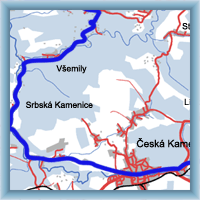 Click to show full-size map