|
|
|
|
|
||||||||||
|
|
|
||||||||||||
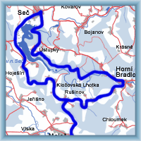
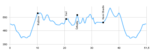
Cycling routes - Round water dam Seč
|
Length: 51,5 km Dificulty: medium Bikes: The trace leads around water dam Seč, the well known recreation resort Chrudimsko and around river Chrudimka. The trace is not difficult. The trail leads on the road besides the part Ústupky - Horní Bradlo. |
|
 Click to show full-size map
| ||||||||||||||||||||||||||||||||||||||||||||||||
| ||||||||||||||||||||||||||||||||||||||||||||||||||

 |
Slovakian mountains |  |
