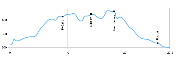
| Dist. |
Location |
Elevation |
Marking |
Description |
| 0,0 |
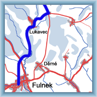
Fulnek |
260 m n.m. |
 |
cycle way 6078, road |
| 6,0 |
Dolní Nový Dvůr |
440 m n.m. |
|
cycle way 6078, crossroad with cycle way 6131, road |
| 9,0 |
Požaha |
480 m n.m. |
|
cycle way 6078, road |
| 14,0 |
Skřipov |
500 m n.m. |
|
cycle way 6078, road |
| 15,5 |
Mostky |
460 m n.m. |
|
cycle way 6078, crossroad with cycle way 6141, road |
| 17,5 |
Jakubčovice |
510 m n.m. |
|
cycle way 6078, road |
| 19,5 |
Nad Raduňkou, cross road |
450 m n.m. |
|
cycle way 6078, crossroad with cycle way 6141, forest path |
| 25,5 |
Raduň |
300 m n.m. |
|
 cycle way 6078, road cycle way 6078, road |
| 27,5 |
Opava, the edge of town |
250 m n.m. |
|
cycle way 6078, road |
| | castle with large park |
|
 Click to show full-size map