|
|
|
|
|
||||||||||
|
|
|
||||||||||||


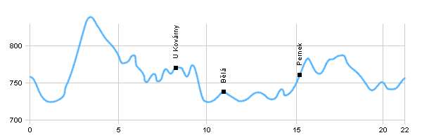
Cycling routes - The circle around Horní Planá
|
Length: 22 km Dificulty: easy Bikes: Easy cycle way leads mainly on roads of III.class |
|
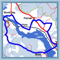 Click to show full-size map
| |||||||||||||||||||||||||||||||||||||||||||||||||||||||
| |||||||||||||||||||||||||||||||||||||||||||||||||||||||||


|

|
|
|
|
|
||||||||||
|
|
|
||||||||||||
|
Length: 22 km Dificulty: easy Bikes: Easy cycle way leads mainly on roads of III.class |
|
Click to show full-size map
| |||||||||||||||||||||||||||||||||||||||||||||||||||||||
| |||||||||||||||||||||||||||||||||||||||||||||||||||||||||
|