Length: 20,4 km
Dificulty: easy
Bikes: cross bike, mountain bike
The trip leads along asphalt and hard surface roads and is suitable for children. There are a lot of interesting sights like the ruin of Rychleby, Pustý Chateau, Čertovy Kazatelny (Devil’s dais) etc.
Drag the map with your mouse 
You can also use the directional arrows in the top-left corner.
Use the keys (+), (-) or the slider to zoom in and zoom out.

|
|
|
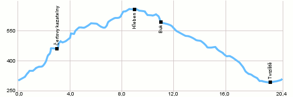
| Dist. |
Location |
Elevation |
Marking |
Description |
| 0,0 |
Javorník |
300 m n.m. |
 |
 6044 6044 |
| 3,0 |
Čertovy kazatelny |
453 m n.m. |
|
6044 |
| 5,7 |
Pod Dubovým vrchem |
582 m n.m. |
|
6044 |
| 9,5 |
Hřeben |
648 m n.m. |
|
6044 |
| 11,0 |
Buk |
587 m n.m. |
 |
Blue tourist's marking |
| 15,5 |
Kaštanová alej |
453 m n.m. |
|
 |
| 17,0 |
Pod Rychleby |
398 m n.m. |
|
 |
| 18,6 |
Račí údolí |
345 m n.m. |
|
|
| 19,3 |
Tvrziště |
288 m n.m. |
|
 |
| 20,4 |
Javorník, náměstí |
300 m n.m. |
|
|
| | Javorník, square - After about 1,5 km a turning to St.Antonín (red touristic track) | | | Kaštanová alej (Chestnut alley) – Possible to visit the ruin of Rychleby | | | Pod Rychleby – Possible to visit Pustý Chateau | | | Tvrziště – Possible to visit a nearby Tvrziště (Stronghold) |
|