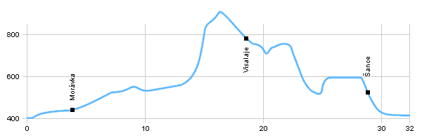
| Dist. |
Location |
Elevation |
Marking |
Description |
| 0,0 |
Raškovice |
400 m n.m. |
 |
cycle way no. 6113, crossroad with cydle way n.6005 and n.46 |
| 1,0 |
Pražmo |
430 m n.m. |
|
cycle way no. 6113 |
| 4,0 |
Morávka |
450 m n.m. |
|
 cycle way no. 6113, wooden path cycle way no. 6113, wooden path |
| 18,0 |
Visalaje |
770 m n.m. |
|
 cycle way no. 6113, wooden path, crossroad with cycle way n. 6112 cycle way no. 6113, wooden path, crossroad with cycle way n. 6112 |
| 28,5 |
Šance |
510 m n.m. |
|
 cycle way no. 6113 cycle way no. 6113 |
| 32,0 |
Ostravice |
420 m n.m. |
|
crossroad with cycle way no. 6007 |
| | by crossroads below the dam is the monument of partisans | | | in the valley creek natural monument Obidová, wet meadows with wetland communities | | | Water reservoir on river Ostravice in the side valley Řečice is Nature Reserve Poledňana |
|


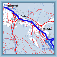 Click to show full-size map