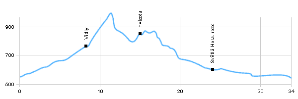
| Dist. |
Location |
Elevation |
Marking |
Description |
| 0,0 |
Vrbno pod Pradědem |
550 m n.m. |
 |
 cycle way 6029 cycle way 6029 |
| 3,0 |
Brook Bílý potok |
630 m n.m. |
|
cycle way6029, crossroad with trail6067 |
| 8,0 |
Vidly |
760 m n.m. |
|
 cycle way6029 cycle way6029 |
| 14,0 |
Karlova Studánka |
800 m n.m. |
|
 cycle way6029 cycle way6029 |
| 15,0 |
Hvězda |
850 m n.m. |
|
 cycle way6029 cycle way6029 |
| 20,0 |
Suchá Rudná |
660 m n.m. |
|
 cycle way6029 cycle way6029 |
| 24,0 |
Světlá Hora, cross road |
600 m n.m. |
|
cycle way6029 - crossroad |
| 27,0 |
Rudná pod Pradědem |
590 m n.m. |
|
cycle way6029 |
| 34,0 |
Bruntál |
540 m n.m. |
|
cycle way6029 |
| | castle, church of St. Michal, wooden view tower | | | mountain village | | | spa town | | | crossroad by Karlová Studánka with restaurant | | | wooden caple |
|


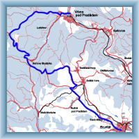 Click to show full-size map