Advertising
West Tatras West Tatras West Tatras


Hiking, Trip to surroundings
Around Bělá nad Radbuzou

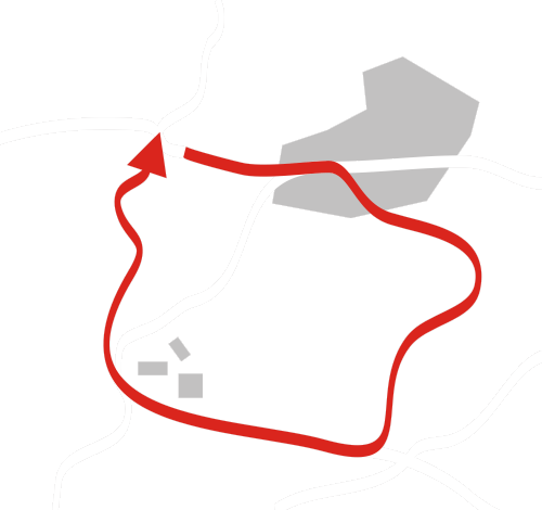
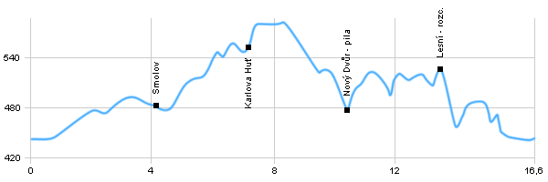
Length: 16,6 km
Dificulty: medium
Circle: YES, Marking: marked

This trip starts in the center of Bělá nad Radbuzou and goes by the blue touristic track by a car road to Smolov village from where it follows the car road for a little longer and then turns right and passes through the valley of Huťský stream to Karlova Huť. In Karlova Huť it turns left to the green track and goes to Nový Dvůr where it connects to a car road for a little while and then still by the green track around Srnčí Vrch (Hill) to crossroad Lesní and Obecní Borek hill back to Bělá nad Radbuzou.

  Back

   Hiking, Trip to surroundings - Around Bělá nad Radbuzou
See the map

 Dist.   Location   Elevation   Marking   Description 
 0,0 
 Bělá nad Radbuzou 
 443 m n.m.         
 0,9 
 Bělá nad Radbuzou crossroad 
 448 m n.m.      crossroad 
 4,2 
 Smolov 
 484 m n.m.        
 7,0 
 Karlova Huť 
 550 m n.m.         
 10,4 
 Nový Dvůr - pila 
 477 m n.m.         
 13,5 
 Lesní crossroad 
 526 m n.m.        
 15,6 
 Bělá nad Radbuzou crossroad 
 448 m n.m.         
 16,6 
 Bělá nad Radbuzou 
 443 m n.m.        


 Bělá nad Radbuzou - The most precious monument of the town is a stone bridge with baroque sculptures from the years around 1720, allegedly imported from Prague gardens. Other important buildings include the Church of Our Lady of Sorrows from the end of the 17th century and the Renaissance chateau.

Hiking, Trip to surroundings - Around Bělá nad Radbuzou


Back

  Accommodation Brod nad Tichou
  Accommodation Salajna
  Accommodation Šumava Mountains
Catalogue of accommodation
 
TOPlist